Introduction
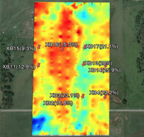
Figure: Soil moisture map generated using the S2 UAS and radiometer payload over an instrumented test site (text indicates in-situ probe name and measured soil moisture content).
Water is a critical resource, especially when it comes to the world's food supply. The ability to accurately and quickly map soil moisture on the scale of individual farms will go a long way to conserving this precious resource. NASA's Soil Moisture Active Passive (SMAP) mission uses satellite technology to monitor drought, predict flooding, and assist in crop productivity. However, the nuances of the Earth's surface can easily be missed by satellite. Obtaining high resolution data in addition to the satellite images would greatly improve NASA's ability to track soil moisture along with providing valuable data to tomorrow's growers.
Beyond satellite calibration, several disciplines including agriculture, land management, emergency management, and military planning can benefit from the ability to determine the soil moisture content at high resolution. When provided with timely and accurate information, water is conserved and crop health is improved, land is more effectively used, and crises such as flash floods can be more accurately predicted and their effects mitigated. Current remote-sensing methods for sampling soil moisture often fail to provide measurements with adequate spatial and temporal resolution, or any indication of moisture content at typical root depths.
A Collaborative Effort
NASA, in collaboration with Boulder-based Black Swift Technologies (BST) and the Center for Environmental Technology (CET), is creating an unmanned aircraft system (UAS) to provide soil moisture measurements from the air. This technology was developed as part of the NASA Small Business Innovation Research (SBIR) program. Using the soil moisture mapping UAS, NASA scientists can gather low altitude measurements from the on-board L-band radiometer with a higher revisit frequency. This can greatly improve satellite calibration by providing localized, high resolution data of areas of interest.
The soil moisture UAS solution consists of the S2 airframe, avionics, radiometer, and supporting sensors specifically designed for the task of accurately measuring soil moisture content, even under dense canopy crops. The primary instrument is a passive microwave radiometer that provides full coverage soil moisture measurements over an area of up to 600 acres per flight. Tight integration of the sensor with the avionics and airframe will enable precise flight control for low altitude missions in the range of 15m-30m above ground level (AGL) required for the sensor to accurately map soil moisture down to ~5cm in depth at up to a 15m resolution.
At the core of the system is the S2 airframe and SwiftCore flight management system. The pair provides a highly capable UAS platform specifically designed to accommodate the next generation of scientific payloads. It has passed NASA's rigorous flight safety review, and contains a level of autonomy and redundancy to ensure data collection can be done routinely and safely. The aircraft limits electromagnetic interference from sub-systems and is capable of low altitude, terrain following flight. In addition, the S2 is designed around a modular architecture, allowing rapid development to accommodate new instruments with the aircraft. Through this innovation, The Soil Moisture Company is able to rapidly develop solutions to meet the needs of the data gathering mission and each customer's unique requirements.
Significance of this Initiative
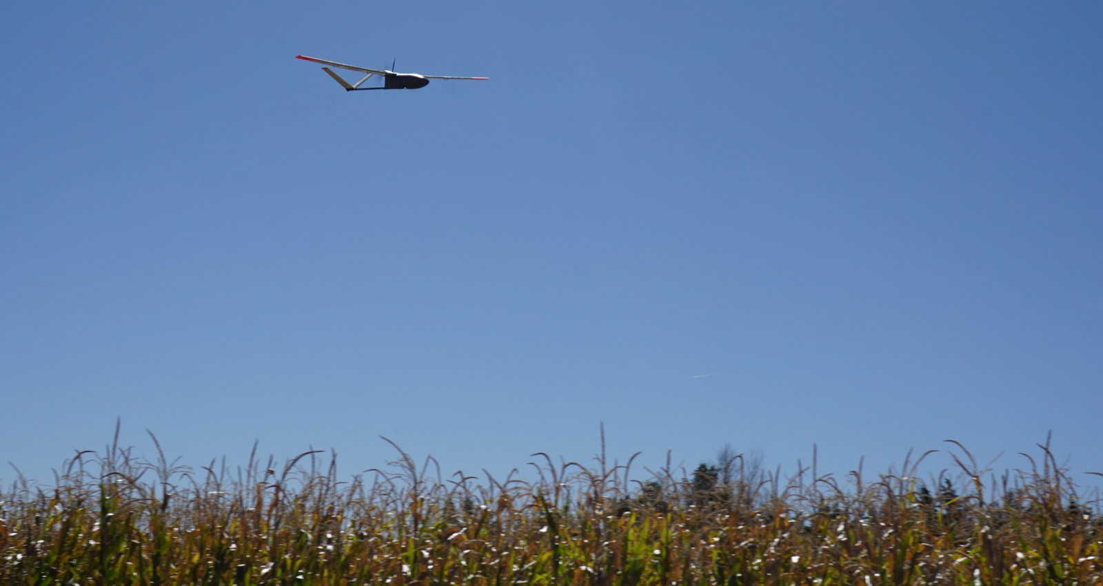
Figure: The Black Swift Technologies S2 skimming the top of crops at a test site during the summer of 2007.
The Soil Moisture Company has been working with several agriculture research groups at the University level along with commercial entities to look into utilizing this unique data to reduce water usage on farms. Two years of flight campaigns have been conducted at a precision agriculture research site with flights of the instrument over various crop types throughout the growing season. This technology is a key attribute for complete systems that take advantage of variable rate irrigation to reduce water usage. It can be further expanded to the application of nutrients and result in lowering the amount of fertilizer used based on the exact water content of the soil which will reduce the ecological effects of fertilizer runoff.
The soil moisture mapping UAS provides a novel platform for conducting Earth science research. This system is capable of mapping soil moisture content at critical depths in a low cost, easy to operate package. It can be employed by current NASA projects to provide valuable localized high resolution data to compare with satellites such as the AMSR-E radiometers mounted on the EOS Aqua satellite and the radiometers specified for the HYDROS mission. Beyond NASA projects, its unique capabilities can also potentially benefit other federal agencies such as agricultural extension service offices, who can deploy the system to provide farmers with data that can improve the productivity of their crops.
The system will also have the ability to support FEMA in better understanding flash flood vulnerability. This utility was demonstrated in 2007 where CET led a NASA funded research effort to map soil moisture in a region of North Texas and Oklahoma that suffered from severe flooding. This data was used to provide alerts and warnings to areas susceptible to flash flooding. The S2 UAS could provide this data at a fraction of the cost and thus improve predictions for flooding events in vulnerable watersheds around the country.
Providing information on vegetation density and soil moisture has a potentially powerful application in support of state and federal agencies seeking to understand, monitor, and fight wildfires. BST is currently contracted to provide wildfire monitoring capability with the S2 aircraft for a project in the Spring of 2018 with other sensors. As the soil moisture mapping UAS matures this technology will benefit forecasting for wildfires.
The measurement of soil moisture is also a key variable to understanding and mapping soil integrity. As soil moisture increases, the soil increases in slipperiness and stickiness while decreasing in strength. One particular consumer of this information, the Army Corps of Engineers currently makes use of soil moisture information to assess soil conditions for heavy vehicle trafficking and aircraft landing operations. The distribution of moisture within a soil determines the traffic that can be supported on the land surface. For off-road movement there is a specific maximum loading that soil can support. The strength of a soil is determined by soil type and soil moisture and can be used to determine the load.
The ability to asses soil integrity is currently hindered by a dearth of high spatial resolution data, with scales usually on the order of kilometers. The S2 with its soil moisture mapping payload can provide up to 15m resolution data, allowing for the models to make use of data on a per vehicle scale. Additionally, the low latency determination of the ability of the soil to support the movement of a vehicle directly will greatly enhance the ability of the armed forces to operate in potentially unstable areas such as terrain in and around rivers, wetlands and coastal regions as well as in regions that are susceptible to thunderstorms and heavy precipitation.
S2 UAS
Figure: The Black Swift Technologies S2 and its soil moisture monitoring payload.
The S2 is capable of conducting fully autonomous flights in unimproved areas. Take-off is fully autonomous and the advanced landing algorithm provides for robust and precise autonomous belly landings utilizing the laser landing system. The S2 has a high operational ceiling, and has been designed for altitudes up to 20,000 ft for NASA science missions. It has primarily been employed for complex science missions, but the overall system will perform well in surveying work, land management, crop damage assessment, and large area ecological studies. The specifications of the S2 are listed in the table below.
The S2 is an aircraft system that was designed around the payload. The nose cone contains a large volume to easily integrate new systems and allow easy access in the field. A standard data and power interface makes the different payloads field-swappable, allowing for spare aircraft without the need for purchasing extra payloads, which can be quite expensive. It is actively being flown for four major scientific field campaigns in both atmospheric science and remote sensing
The S2 utilizes the SwiftCore Flight Management System, comprised of the SwiftPilot, SwiftStation, and SwiftTab user interface, along with support electronics. The entire system is designed for ease of use along with accurate flight tracking, even in high winds. The SwiftCore is designed by BST and is entirely made in the USA. The SwiftCore has been approved and used for major scientific missions by NASA, deployments by NOAA, and by a growing list of commercial companies.